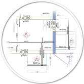
Topographic Diagram
Our technical construction office undertakes to draw up topographic diagrams, which outline at an appropriate scale the land surface and the constructions on it, as well as any other information required by the current legislation as per the purpose that the topographic diagram serves.
Indicative circumstances when a topographic diagram may be required:
- Drawing up a contract transferring or introducing real rights on an estate.
- Forestry Act that characterizes land as forest land.
- Inspection of the plot or farmland integrity and suitability for building.
- Delineation and demarcation of an estate.
- Division of residential or agricultural land in horizontal and vertical properties.
- Plot or farmland dependant on the State Coordinate System (Greek Geodetic Reference System 1987 - EGSA 87).
- Issuance of Building Permit.
- Plotting for the execution of construction work.
Our topographical work is carried out with innovative topographical equipment and methods of great accuracy, with the use of geodetic station - total station Topcon OS-103 and the use of geodetic satellite receiver identifying locations - Topcon HIPER-V.


ArchitectuRal Design
Structural Design

Building Permits

Topographic Diagram

Engineer Certificates

Copyright © 2014 Corfuhomeconstructions.com